
Since a few days ago the first data from Sentinel-2B is publicly available.
Data access is offered through a separate instance of the download infrastructure so you will have to adjust any download scripts or tools you might have. It seems Sentinel-2B is going to be operated in the same way as Sentinel-2A, meaning with priority of Europe, Africa and Greenland and less frequent coverage of larger land masses of the rest of the world. I added the daily numbers from Sentinel-2B to my satellite image numbers page, right now image recordings are not quite at the same capacity as with Sentinel-2A and images from before the last days of June are not yet available.
When Sentinel-2B is recording the same amount of data as Sentinel-2A it is supposed to reduce the typical recording interval to half – from normally 10 days in Europe and Africa to 5 days. The orbit overlap at high latitudes also means that for Greenland and the European Arctic areas north of 75° latitude up to 82.8 ° will be covered daily compared to 79.3° previously – since ESA in contrast to the USGS does not reduce the number of recordings at high latitudes due to the overlaps.
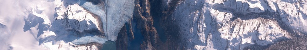
Here two sample images from the last days:

Upsala Glacier, Patagonia by Sentinel-2B

Sevastopol, Crimea by Sentinel-2B
Apart from the new Sentinel-2 images we now get public access to a few more Sentinel-3 data products here, here and here. This is more or less as expected although these are mostly relatively specialized products and not the kind of general purpose Level 2 products you might expect when you look at the MODIS products for example. I am probably going to write about this in more detail soon.
A short note explaining the different processing levels of satellite images:
- Level-0 is usually more or less the raw data coming from the satellite.
- Level-1 commonly includes basic calibrations of the characteristics of sensor and optics as well as geo-referencing.
- Level-2 is mostly about compensating for undesired influences in the image, especially those resulting from the atmosphere, the view perspective and illumination. The aim is usually to characterize the earth surface in a way that is independent of the specific recording situation of the satellite and might already be targeted at a specific thematic application.
- Level-3 is less clearly defined and usually refers to time aggregated data, further interpretations of the data or combinations with other data sources.
Some might remember the trend i postulated some time ago regarding the timing of Sentinel program satellite launches and data releases. We can now carry this forward a bit:
- Sentinel-1A: Launch 3 Apr 2014, public data access since 9 May 2014 (1 month)
- Sentinel-2A: Launch 23 Jun 2015, access since end November 2015 (5 months)
- Sentinel-1B: Launch 25 Apr 2016, access since 26 Sep 2016 (5 months)
- Sentinel-3A: Launch 16 Feb 2016:
- OLCI L1 access since 20 Oct 2016 (8 months)
- SLSTR L1 access since 18 Nov 2016 (9 months)
- partial OLCI/SLSTR L2 access since 5/6 Jul 2017 (>16 months)
- further L2 products: 16+ months and counting…
- Any data from before 20 Oct 2016: missing and unclear if it will ever be available.
- Sentinel-2B: Launch 7 Mar 2017, access since end 5 Jul 2017 (4 months)
As you can see the trend is broken and i am sure everyone appreciates the speedup with Sentinel-2B compared Sentinel-2A but the release policy on Sentinel-3 is – how should i put it: remarkable. Remember the level 2 products are all things that have been routinely produced for more than a year – just not being made available publicly despite the regulations requiring that. You might say that releasing level 1 data is enough and everything else is just optional addon services but if you look at MODIS data use for example i am pretty sure that more than 90 percent of MODIS data users use products of level 2 or above. So for the purpose of ensuring a wide adoption of Sentinel-3 data use (and i would assume at least the EU commission has this goal) holding back level 2 data is just brainless.