I have updated the Franz Josef Land map with new data based on mostly 2016 Sentinel-2 imagery and also using a relief rendering primarily based on ArcticDEM data as a test case for the new data set.
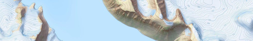
Franz Josef Land is relatively well covered in ArcticDEM with only a relatively low fraction of data gaps but still contains a lot of artefacts that would severely ruin any map rendering based on the data directly. The artefact detection is only semi-automated, identifying data errors through analysis of the data alone is not completely reliable and requires manual review for good results. In addition to masking gaps and artefacts and filling those areas with a combination of other data sources and shape-from-shading i also compensated for the elevation calibration problems described in my general report on ArcticDEM and flattened the water areas.

ArcticDEM original data with artefacts

ArcticDEM processed
Since the map production process itself with label placement and generalization is fully automated updating the data basis and replacing the relief data source is fairly simple which is extremely useful in particular for a map of an area that changes as fast as this one.
The results can be found in the Franz Josef Land map.
If you would like to create custom maps based on this data or would like to use the data for other purposes you can also find it on services.imagico.de.