
This year’s summer weather in Northern Greenland has been quite good, much better than 2013 so a lot of good quality Landsat images are available to assemble a mosaic of the Northeast Greenland coast – one of the most remarkable but at the same time least accessible regions of the planet:

The view covers large parts of Northeast Greenland from the Independence Fjord in the north to the Storstrømmen Glacier in the south. The whole area is part of the Northeast Greenland National Park.
A lot of interesting features can be observed in this image and i will explain some of them here. First of all the Ocean off the coast here is the most important connection of the Arctic Ocean to the outside, responsible for most of the water exchange between the Arctic and warmer Ocean areas. As a result this is a key area for the dynamics of the world climate. The East Greenland Current carries cold water from the Arctic ocean towards the north Atlantic throughout the year here while further to the East near the coast of Svalbard the West Spitsbergen Current brings warmer water northwards. As a result a lot of sea ice can be observed on the water near the Greenland coast even in Summer while the west coast of Svalbard has relatively mild climate even in Winter. The dynamics between the different currents, the sub water relief and the winds create interesting patterns visible in the sea ice like in this MODIS image from around the same time (which has also just been featured on NASA EO while i was putting together this post):

Back to the first image – the cold ocean current does not only lead to large amounts of mobile sea ice on the open ocean, it also results in some of the coastal ice persisting throughout the summer in many years. This can be seen well near the center and on top of this view, north of the glaciated Kronprins Christian Land peninsula. As I shortly mentioned in relation to the Arctic Mosaic previously these two areas of sea ice have at least in parts been persistent for the last 6 years. In the north the sea ice is attached to the coasts while in the south the ice is probably pinned in place by icebergs grounded in shallow water there.
On the left side of the image you can see the eastern edge of the Greenland Ice Sheet. The most important outlet glaciers of the ice sheet in the northeast are located in the center – the Nioghalvfjerdsbrae and the Zachariae Isstrom. The front of the Nioghalvfjerdsbrae is shown in the following crop. The tongue of the glacier is fairly flat and floating on the ocean. You can see various meltwater channels following the complex patterns in the structure of the ice. The dynamics of floating glacier tongues are not only influenced by the inflow of ice from the top and the calving of icebergs at the front but also to a large part by melting and freezing at the bottom. As a result the floating glacier tongue is not built purely from glacier ice but probably also contains a significant amount of frozen sea water. At the front of the glacier you can see a number of small islands, some ice free, others run over by the glacier, stabilizing the glacier front at this location.

The front of the Zachariae Isstrom on the other hand has retreated a lot in recent decades – this has been discussed in more detail on the glacierchange blog. Here a crop of the current glacier front. The glacier is on the left and the water in front of it between the various icebergs is mostly frozen with different colors indicating different age of the ice. On the right side you can see a part of the former floating glacier tongue that is now separated from the glacier but that has not disintegrated into icebergs like the main tongue further south. Like in case of the Nioghalvfjerdsbrae this is a mixture of glacier ice and sea ice.

Formerly the glacier ice here extended much further, up to the outmost islands near the coast. In most years the coastal sea ice prevailed along the whole coast in summer. The whole situation is not unlike that of the Matusevich Ice Shelf. Here two images of the same area from 1985 and 1975 showing the difference.


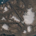
Three more crops from the mosaic, the first from the Romer Sø lake on Kronprins Christian Land with remains of the ice cover from the winter.

The second showing the meltwater lakes on the ice sheet.

and the final one from the north at the south coast of the Independence Fjord.

As usual the image is available on services.imagico.de for prints and licensing.