
The title of this section should be interpreted loosely this time – i have not discussed new developments in the domain in general for some time now so some of the news are more than a year old already.
There were a number of of recent and are a number of upcoming satellite launches both in the Open Data domain (in particular Landsat 9 of course) and in commercial Earth observation. In the latter we have had in particular the first two of four Pleiades Neo satellites launched (May 20 and August 16) which are going to offer increased resolution and higher recording capacity compared to the existing two Pleiades satellites. Maxar has been showing their plans for a new constellation of more lightweight high resolution satellites making use of economics of scale in building them and offering more flexibility in recording than single and more heavy system like they are predominantly using right now. But there seems no definitive launch date yet. Still the Pleiades Neo launches evidently will put pressure on them. Planet Labs has also started launching an updated version of their micro-satellites offering additional spectral bands. As usual they have been very tight-lipped in public about this though.
In terms of newly available open data satellite imagery i want to mention in particular the Brazilian CBERS-4A (launched December 20, 2019) and Amazonia-1 (launched February 28, 2021) satellites. It seems the data released by the National Institute for Space Research (INPE) is all available under CC-BY-SA which is more restrictive than the licenses of other open data image providers but still the most notable entry in the open data imagery domain from outside Europe, North America and Japan so far. What is not clear is if the data published by the INPE is all the data recorded by the satellites or if they release only data selected to be published as open data and there is also unreleased data that is not available freely. Considering the data published is mostly limited to South America that is not an unlikely scenario.
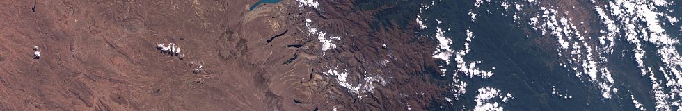
Amazonia-1 image example over southern Peru/Bolivia – whole scene
The Amazonia-1 satellite with its 850km swath and 60m resolution fills a noticeable gap in the European, North American and Japanese systems between the high resolution systems (resolution better than about 50m but swath width less than about 300km) and the low/moderate resolution systems with swath width of more than 1000km but resolutions of 250m or worse.

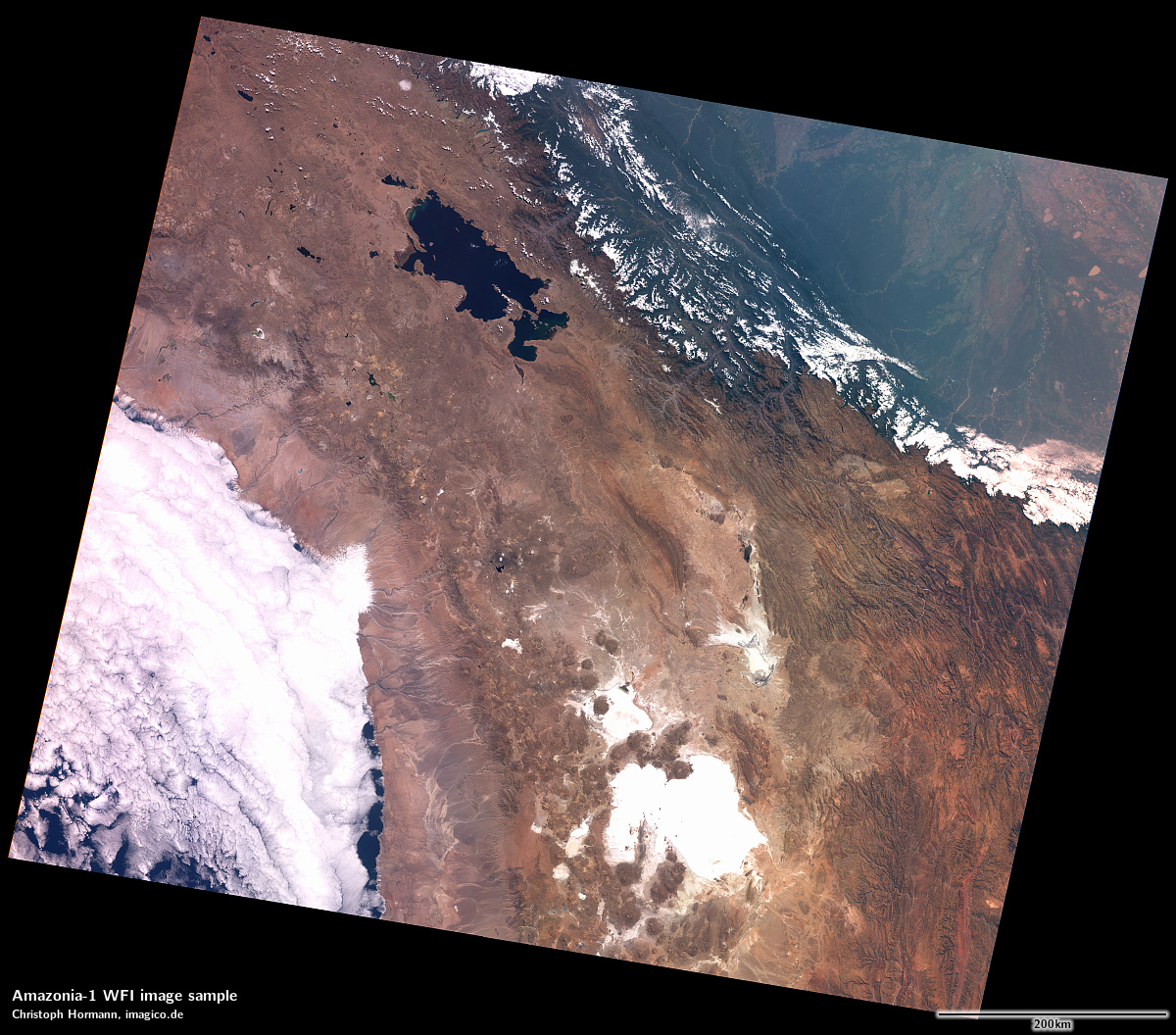
Amazonia-1 image sample – magnified crop
The actual Amazonia-1 image sensor is not particularly advanced by today’s standards – dynamic range seems to be comparable to Landsat 7 – with the same tendency to saturate the sensor on bright features. It seems to be using 10-bit AD conversion.
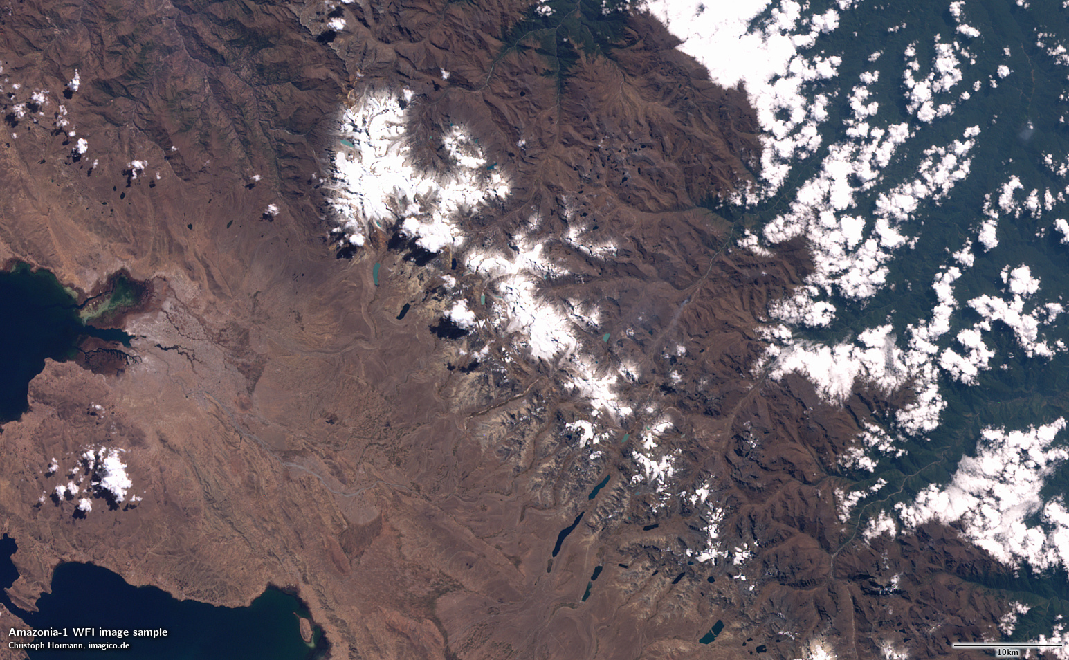
Amazonia-1 image sample – full resolution crop
There also seems to no radiometric calibration data available so far – just the raw sensor values. But still this is a fairly impressive source of imagery available there with the combination of a fairly wide field of view with a moderately high resolution and it would be great to have this available also for areas outside the region in South America covered so far.
Targeting the same gap in available imaging system is another experimental system – SeaHawk – that was launched in 2018 already and that became more prominently publicized recently. SeaHawk is a less than 5kg micro-satellite that records a 216km swath at 120m resolution. That is less ambitious than Amazonia-1 and provides less nominal coverage than a single Sentinel-2 satellite but at that form factor this is pretty impressive, especially also in terms of image quality.
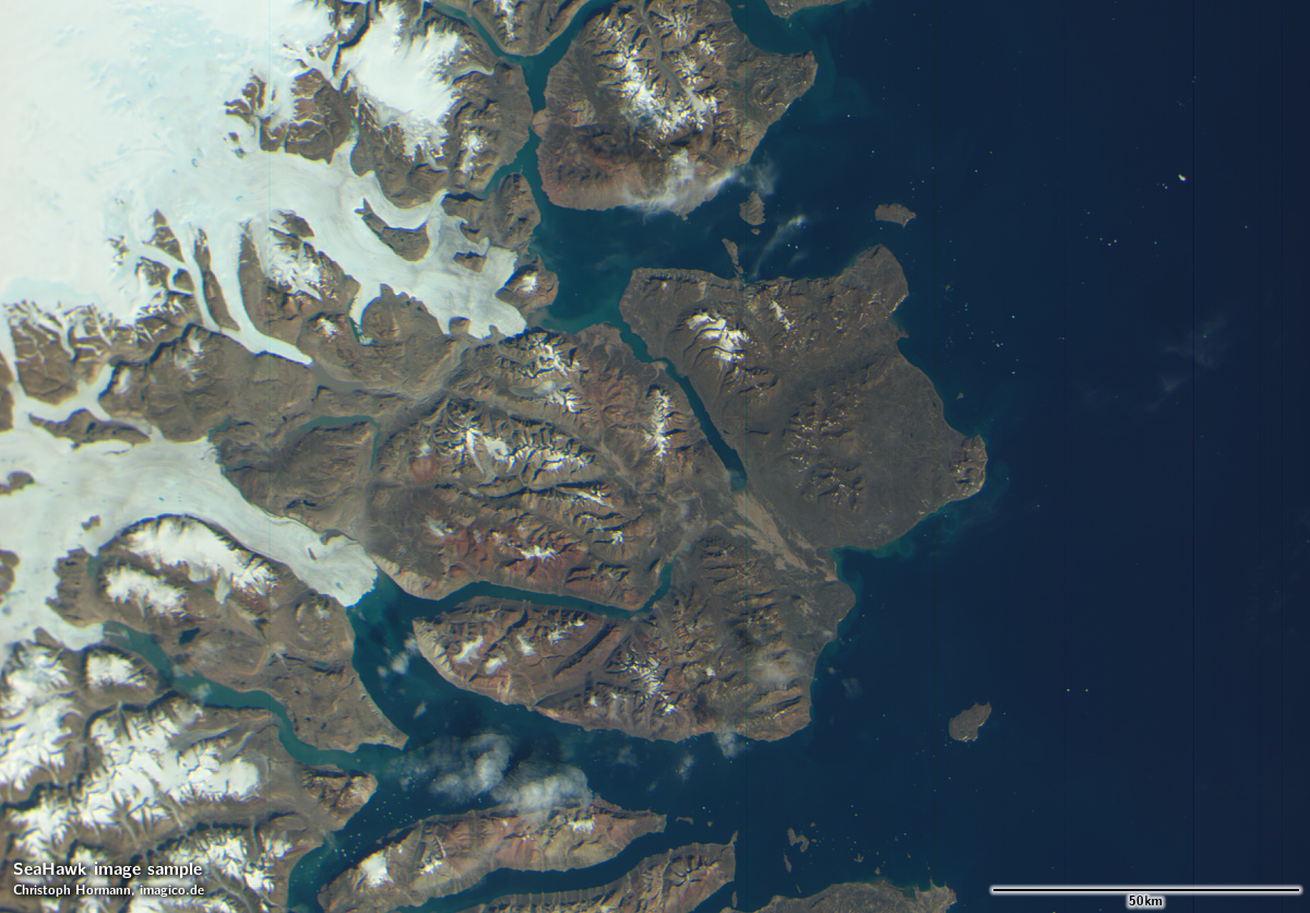
SeaHawk image sample from Eastern Greenland

SeaHawk image sample from New Caledonia
If you look at the images available more closely you can see various issues and flaws, in particular:
- a significant level of banding and striping due to non-uniformity in the sensor. This could probably be partly compensated by better per-pixel calibration but still this is on a level significantly worse than larger current satellite sensors.
- a significant decline in resolution towards the swath edges which is clearly the result of limitation of the optics and not of the view geometry (larger viewing distance at the edges – well known for wide angle systems like MODIS and VIIRS) alone.
- a significant mismatch between the spectral bands leading to color rims at sharp contrast edges.
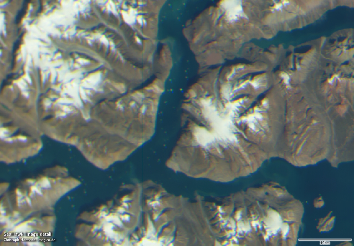
SeaHawk image sample magnified crop
The most significant operational issue however seems to be the poor out-of-the-box geolocation accuracy of the images. The raw Level-1 data you can download comes without any geolocation data and so far they seem to be manually geocoding the data on the coastline. Micro-satellites like this have only very limited ability to determine their own orientation in space and therefore limited ability to know where exactly they are looking. That lack of accurate information severely limits the ability to properly and accurately geocode the image data. A more detailed discussion of the matter is provided by the operators.
In a quite similar direction of miniaturization goes the PROBA-V plus one project – meant to be a follow-up on the ended PROBA-V – which unfortunately despite being paid with tax money has never been fully open data. It will be a good test case to see if the organizational culture at ESA is changing in light of the Copernicus program (where the open data policy has been imposed from the top by the EU Commission) or if the influential people in and around ESA still prefer to keep the bulk of the data exclusive to themselves and those deemed worthy.
Following up on my posts on Sentinel-3 image use and the severe issues with geolocation data in the SLSTR files – ESA has in late 2019 apparently finally noticed and fixed the problem. Newer files produced (produced after early 2020, indicated by a ‘004’ version string in the file name) do not contain this error any more. Older Sentinel-3B data has also been reprocessed but Sentinel-3A data not yet.
I will follow up on this in a bit more detail in a separate post probably.
Of all the optical earth observations systems in the EU Copernicus program i had not yet looked at the Sentinel-5P satellite. It is of relatively little value for the work i am doing but for completeness reasons i had a closer look. Sentinel-5P features a low spatial resolution hyperspectral sensor which records data in particular about the atmosphere and focuses on the UV and blue domain. It would be great for considering and demonstrating the effect of different spectral band designs of multispectral sensors on visualization of the Earth but unfortunately its spectral coverage has a huge gap right in the middle of the visual range where you would typically have the green band.

Sentinel-5P L1B data false color visualization showing data from Sept 10, 2021 at around 305nm, 390nm and 475nm
The illustration above shows the visualization of the data of a single day in the UV-Range and in the blue spectrum in a false color display. The strips along the flight direction of the satellite are caused by the different scattering characteristics depending on illumination and view direction. A large part of the signal in the ultraviolet is caused by scattering in the atmosphere. Different gases and aerosols have different scattering and absorption characteristics depending on the wavelength – visible on that day in particular in the mid west of the USA where the smoke from fires shows up in strong red-brown tones. The Sentinel-5P sensor offers very detailed spectra of every pixel recorded. Overall more than 150GB of L1B data were processed for the production of this illustration (and that is just three of eight spectral bands).
Sentinel-5P by the way is the only satellite from the Copernicus program that covers the whole planet surface during a single day.
Finally a bit of seriously bad news – NASA has last year announced that the Terra satellite is nearing the end of its life and will – due to the lack of fuel (i discussed this in more detail for EO-1 in the past) – start to drift in its orbit. It has meanwhile exceeded nominal specifications for the recordings and will probably reach a 15 minute difference in timing/position of its images by September 2022 and will likely cease producing usable images by 2025 latest.
I will probably write a bit more about the Terra satellite and its significance for the historic development of Earth observation from space as well as its present day significance. In particular i would also like to discuss the MISR instrument. Most people know Terra in particular for the MODIS and ASTER sensors and MISR – being somewhat in the shadow of the more popular MODIS is one of the most underrated and underused Earth observation systems currently available.
I have also updated my diagram of Multispectral Earth Observation satellites with many of the systems mentioned above and a few others as well as some updates and fixes for existing data.
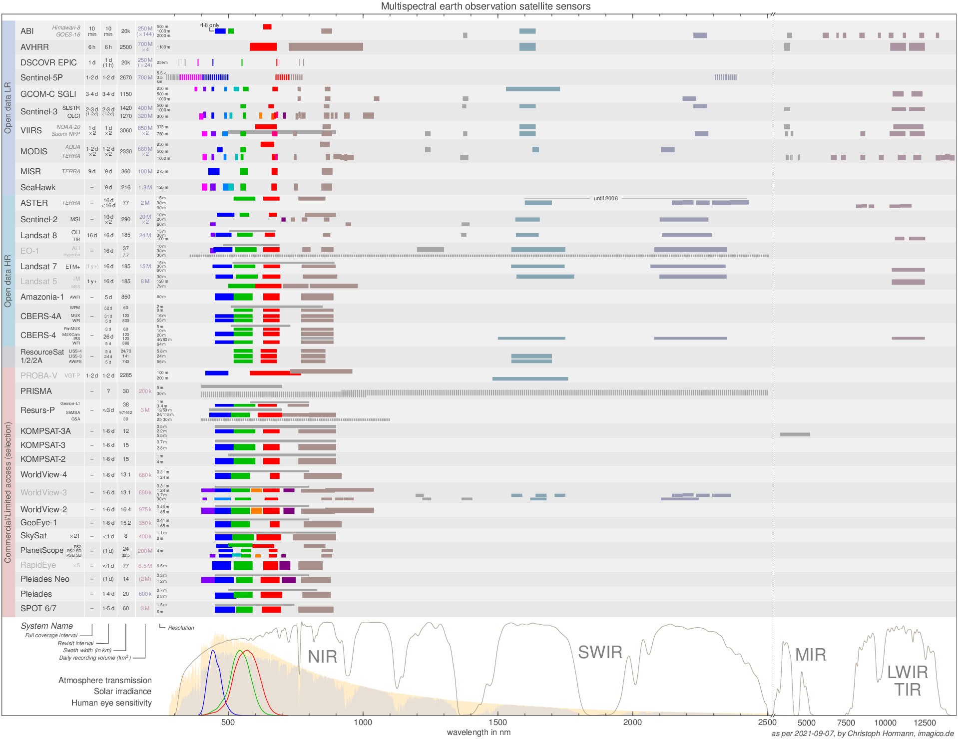
Multispectral Earth observation satellite sensors – September 2021