Some news that might be of interest for some of my readers – without any attempt of completeness.
- The Sentinel-2 package format has changed – again. This change is rather small and will not significantly affect most users. The interesting and funny thing however is the second time stamp saga from the previous change now seems to have gained another twist – now the second time stamp is specialised to ensure a deterministic repeatable name across time for the same product. In other words: It does not have a meaning any more, it is just there to be able to distinguish between several packages with different data but otherwise the same name (which can happen at data strip boundaries).
- Another thing on Sentinel-2 – it has not been widely advertised but there is a data quality report on Sentinel-2 data updated in more or less regular intervals here. You need to be careful when reading this of course. Regular updates do not mean all information in that report is complete up-to-date. And you have to know how to interpret the information given. Take for example the absolute geolocation accuracy (which i have written about recently as well) – This can only be reliably measured for areas where you have accurate reference data – which does not usually include regions where accuracy tends to be bad. So the <11m at 95.5% confidence is likely not based on an unbiased set of reference locations. The reference locations are not published of course – neither is the source of the reference data used.
- The USGS is starting to introduce what they call Landsat Analysis Ready Data. This essentially means Landsat imagery reprojected to a common coordinate system for the Unites States and distributed in tiled form. I am not going to review this data since i think this kind of product is conceptually and technically a dead end. It is by definition a regional data product they cannot extend to global coverage and performing double resampling (from the raw Level 0 data to the UTM grid of the orthorectified Level 1 product and then again to the Albers Equal Area projection of the ARD grid) is wasteful and unnecessary. There are obviously advantages for processing and using data in a common grid for larger regions but if the solution for that limits you to areas within the Unites States that is not really a universally usable approach.
- In the field of commercial earth observation Planet Labs has launched six new SkySat satellites – those are the somewhat larger satellite systems from their acquisition of Terra Bella from Google. I briefly mentioned them in my discussion of Planet Labs some time ago. There is very little information publicly available on actual operation of these satellites. They claim a recording capacity of 185k km^2 per day for the whole fleet of 13 of these satellites. That is not much. With a recording swath width of 8km that amounts to less than 2000km recording length per day per satellite or about 20 seconds of recording per orbit. If this is to be increased in the future is unknown but at the moment it seems that these satellites – being positioned to record at different times of the day and together with a monochrome video recording ability – are mostly intended for what you might call event photography from space.
- There are two upcoming launches of Earth observation satellites – for November 14 there is the planned launch of JPSS-1 which carries a second VIIRS instrument in addition to the one on Suomi NPP launched in 2011. And in late December there is the planned launch of GCOM-C. Both have been subject to delays – JPSS-1 was originally supposed to launch in 2016, GCOM-C in 2014.
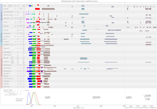
I updated my satellite sensor chart accordingly. Note i still could not get myself to specify a full coverage interval for the PlantScope satellites. They now show a decent monthly coverage of >90 percent between -60 and 75 degrees latitude for the combination of RapidEye and PlantScope but full coverage means full coverage for me. And demo or it did not happen.
