
In February i reported the launch of the Sentinel-3A satellite and now the data finally starts to get available to the public.
According to the published schedule we now get the OLCI level 1 data, the SLSTR level 1 data is going to follow in November and higher level products are indicated for some time next year.

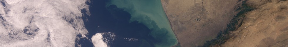
Color rendering of one of the first public Sentinel-3 OLCI data sets
Some readers who follow earth observation satellite deployments and operations might be astonished since Sentinel-3 images have been shown quite frequently by various parties for months already. This is because since May data has already been made available to so called expert users. None of the satellite image experts i know of is apparently part of this illustrious circle – indicating the expertise to qualify for this is different from what is usually understood as being an expert. This data was called ‘sample data’ but unlike normal sample data this was produced on a regular basis for the whole time – a somewhat creative use of the term ‘sample’.
This whole procedure is quite remarkable since the regulatory requirement of the Copernicus program is clearly that all data from the Sentinel satellites will be made available to everyone without access restrictions beyond basic registration. By declaring the satellite – or more precisely the data processing system since the satellite passed its in-orbit commissioning review in July – not yet operational this requirement is apparently circumvented.
You might call this paranoia on my part but the signs that a lot of influential people around the Copernicus program are largely uncomfortable with the whole open data aspect is quite visible in many things. For example look at the dates for the different Sentinel satellites launched to date – there is a clear trend visible:
- Sentinel-1A: Launch 3 Apr 2014, public data access since 9 May 2014 (1 month)
- Sentinel-2A: Launch 23 Jun 2015, access since end November 2015 (5 months)
- Sentinel-1B: Launch 25 Apr 2016, access since 26 Sep 2016 (5 months)
- Sentinel-3A: Launch 16 Feb 2016, partial access since 20 Oct 2016 (8 months)
Of course the first data released for Sentinel-1A was highly experimental and there were massive changes in the whole data distribution system afterwards. But that’s natural considering the lack of experience with public data distribution.
In defense of those in charge – the volume of data that needs to be made available for download is quite significant. For Sentinel-2 there are about 200-300 ‘scene’ packages per day (the old 300km packages, not the new single granule ones) which – with an assumed average size of 5GB amounts to about 1-1.5TB per day. For Sentinel-3 estimates are 28.5GB (OLCI) and 44.5GB (SLSTR) per orbit which amounts to more than 1TB per day for the basic level-1 data – not counting higher level products or the different near-real-time and long term versions. And the near-real-time product is supposed to be made available within three hours of recording. Given the difficulties that already showed regarding reliability of the data distribution with Sentinel-2 it is not really astonishing they are not too eager to open this fragile infrastructure to the public with even more data. But the ressources that go into the public data distribution component of the Copernicus program of course reflect the importance this has for those in charge – and it is not that the requirement to scale to this level was not already clear several years ago.
The situation might also be related to the fact that Sentinel-3 unlike Sentinel-1 and 2 is operated by EUMETSAT and not ESA (though ESA will distribute parts of the data). I wrote about the lack of an open data culture in ESA before but due to their scientific mission they at least superficially have to try to appear open.
EUMETSAT on the other hand is an intergovernmental organisation for running weather satellites for the European national weather services. Since it is inefficient for each of the countries in Europe to operate their own weather satellites they joined together. The concept of EUMETSAT is that countries joining it get free access to the satellite data for the national weather services for their own use. They are also allowed to license this data to third parties as licensing agents but are bound to the fees set by the EUMETSAT management. So essentially EUMETSAT has two purposes:
- cost reduction by operating weather satellites together for the national services
- monetarizing on the data produced by selling it to commercial users as a cartel
As a result policies for European weather satellite data are among the most restrictive world wide because it is explicit policy of the operator to try monetarizing on any uses of the data for non-governmental purposes – contrasting quite extremely for example to the Japanese with Himawari 8 which has full free public access to the data.
You might notice the irony in such an organization now being put in charge of operating a satellite with mandataory full open data access. Sentinel-3 does not compete directly with geostationary weather satellites of course but EUMETSAT is also operating other polar orbiting satellites.
Regarding the data itself – i have not looked at it in detail yet, will probably do a more thorough review later but likely not before also the SLSTR data is available. Since it comes in a non-standard form (netCDF format without normal georeferencing information) it will be fairly complicated to use with normal tools. What can be said so far is however that what is available is fairly incomplete. Since OLCI is visible and NIR wavelengths only night acquisitions are not of much use but they do not even have full coverage of the sunlit part, compare the footprints:

with the current Terra-MODIS coverage:

The more narrow swath and larger gaps near the equator are normal and expected but the fact that coverage ends fairly early towards the poles is not. If this is based on a sun elevation cutoff or some other criterion is unclear to me – just like if this is only a limitation to the data made available or if this represents the actual acquisitions. This will however likely limit data at high polar latitudes to a very small time frame of just 3-4 months per year.