MapBox some time ago started promising attempts to produce a new cloud free mosaic from MODIS satellite images and has now made available the result for use by their customers as well as the OSM community.
A bit of background information – MODIS is an imaging system on board of two NASA satellites in an orbit identical to Landsat which I just wrote about. One of the satellites (named Terra) has a morning window of view like Landsat while the other one (Aqua) records image from the afternoon. Since the MODIS instrument has a much larger field of view than Landsat (and correspondingly a lower resolution) it can record nearly the whole planet surface every day (with small gaps at the equator which are covered every second day). MODIS also has a more accurate sensor than the old Landsat TM/ETM system producing 12 bit data in 36 spectral bands. Below you can see an up-to-date global composite of a single day (May 9 2013). The lack of coverage in the very south is due to the polar night.

The mentioned characteristics have lead to MODIS data being widely used to produce global cloud free mosaics – the most well known being the Blue Marble and Blue Marble Next Generation images I wrote about previously. Now BMNG is already more than 8 years old and the MapBox attempt looks like an interesting update. It should be clear that the amount of data that needs to be processed for this is enormous. A single global image at the MODIS visual bands resolution is already several gigabytes and to achieve cloud-freeness in tropical regions you often need a huge number of individual images. I am doing this myself frequently for my 3d views at a smaller scale. So the following critical remarks are not meant to diminish the work of MapBox – but meant as constructive criticism.
Below you can see the new MapBox image for the whole globe (first) in comparison to the Blue Marble Next Generation (second)


MapBox has decided to process the images for much stronger and brighter colors. This seems to have been a last minute decision since the previously shown images are closer to the BMNG image – below first the published version and then the original preview and last the BMNG:


I can only guess that people at MapBox think the more saturated colors are more appealing to their customers. But you can also see in this example the downside of such processing – the bright areas of snow are blown and colors already strong in the original data (like deep greens) are out of gamut in the final image. Note the BMNG image is tone mapped as well, it is however done in a way avoiding blown colors and maintaining the overall color accuracy.
The other thing MapBox apparently changed for the images released is they cut away the ocean and replaced it by a uniform color as visible in the above example. This is understandable since it is much more difficult to produce a uniform cloud free ocean image than doing this for the land since the ocean changes much more rapidly. The ocean can also be disturbing when the focus of the map is on the land. For clipping they seem to have used a quite old and not very detailed land-ocean mask though (specifically not the current OpenStreetMap coastline). This is well visible in northern Greenland:

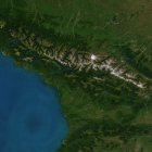
Another thing I observed is that MapBox does not seem to have compensated for atmosphere scattering. To produce a cloud free image they of course selected the data with least influence from the atmosphere but the overall atmospheric scattering present at all times that leads to a different appearance of mountains and valleys is maintained. This can be seen in the following example of the Sichuan Basin in China:

In comparison the BMNG version:

Keeping the atmosphere might of course be intentional – this makes it quite different from the BMNG image though which tries to approximate the ground level appearance without atmosphere. What is also visible in this crop is that seasonal variations are not processed very consistently. In contrast to the BMNG which comes in different versions for every month of the year MapBox only produced a single image representing varying seasons across the globe. In the mountain areas in the western part of this crop for example the snow minimum, the vegetation maximum and the cloud cover minimum are reached at different times of the year and the colors shown represent a mixture of all these seasons randomly changing, sometimes at a very close distance.
Finally it is interesting to see how well the claimed cloud-freeness has actually been accomplished. The key areas for cloud elimination are usually the tropics. The following example shows parts of Ecuador in South America in the MapBox image (left) and in BMNG (right).


Note few white dots in the mountains are actually glaciers but most white is clouds here – in both images. It seem while the eastern side of the mountains is somewhat better there are actually more clouds in the MapBox image than in BMNG on the western side. Although this is an extremely nasty region concerning clouds of course it still seems strange, especially considering the data basis used by MapBox is probably much broader than for BMNG.
Since I am looking at this primarily for the purpose of geovisualization the strong color tone mapping applied to the images released is the most problematic and in the end somewhat disappointing aspect. I can’t help but notice that the appearance of the MapBox image (first example above) is actually quite similar to the original Blue Marble 2002 image so in a way is a step backwards. MapBox certainly has its customers in mind here and thinks for their purposes the chosen tone mapping is optimal. And i also know a lot of people preferred the coloring of the Blue Marble 2002 to the BMNG so they could be quite right with their assessment. The problem is however that for anyone who does not agree and wants to process the colors differently (as it can be done to some extent in the MapBox tools) the previous processing applied to the images by MapBox has already destroyed a lot of information that could be useful for a custom rendering.